Greenland is part of the Arctic region. It is the world’s biggest island, around 836,330 sq miles in size (2.1 million sq km). Most of the land is covered by ice and glaciers and it is home to almost 57,000 people.
Since the 1970s, the region has been warming at double the global mean rate. On Greenland, average annual air temperatures between 2007 and 2012 were 3°C warmer, compared with the 1979 to 2000 average.
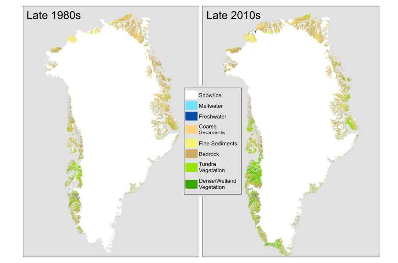
An estimated 11,000 sq miles or 28,707 sq kilometers of Greenland’s ice sheet and glaciers have melted over the last three decades.
The total area of ice loss is equivalent to the size of Albania, and represents about 1.6% of Greenland’s total ice and glacier cover. Where there was once ice and snow, there is now barren rock, wetlands and areas of shrub.
Over the three decades, the amount of land with vegetation growing on it increased by 33,774 sq miles (87,475 sq km), more than doubling over the study period.
The loss of ice affects land surface temperatures because of albedo, which is the measure of how reflective a surface is.
Snow and ice are good reflectors of the sun’s energy hitting the Earth’s surface and this helps to keep the Earth cooler. As the ice retreats, it exposes bedrock which absorbs more solar energy, raising the temperature of the land surface.
Similarly, as ice melts it increases the quantity of water in lakes. Water absorbs more solar energy than snow and this also increases the temperature of the land surface.
The analysis shows a near quadrupling of wetlands across Greenland, particularly in the east and north-east. The wetlands are a source of methane emissions.